Potosi Guide
Information about Potosi Department
Information about Potosi.
1. Creation.
Created by Supreme Decree on 23 January 1826.2. Population.
The department of Potosi has a population: 815,013 (INE, Census 2010).3. Surface.
Its area is 118,218 km2.4. Geography.
The department of Potosi is located in the southwest of the Republic of Bolivia.5. Limits.
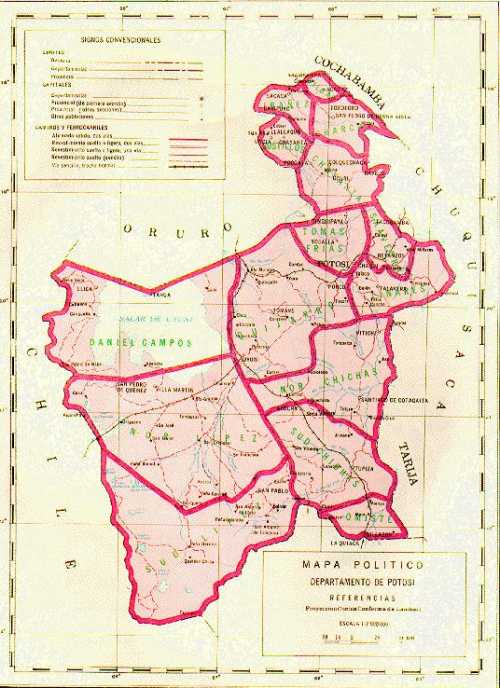
To the north, with the departments of Oruro and Cochabamba, on the south, with Argentina on the east by the departments of Chuquisaca and Tarija and west by the Republic of Chile. The city of Potosi is located on the slopes of the Cordillera Oriental of the Andes.It is near the city of Lhasa in Tibet, the highest city in the world and is located between 16 30'30 "south latitude and 68 112'00" longitude west of Greenwich.
Northwest of the department, the lowest part of the plateau, is the impressive Salar de Uyuni. All this region is characterized by the presence of geysers, fumaroles, mud volcanoes, hot water springs and sulfur deposits. The landscape aggressive Western Cordillera tempered by the presence of lakes and valleys nestled between the mountains.
6. Orography.
By the department of Potosi are both the western and the eastern cordillera. In the northeastern region is the lowest part of the plateau: the Salar de Uyuni (3656 m).In the north is the Cordillera Llica. In the West, North - South, Range Sillillica appear, belonging to the volcanic mountain range. In the southwest is the volcanic string that differentiates the volcano Licancábur (5.930 m.), the Ollagüe (5.810m.) and the milestone cumbre de Paroma (5.739m.). The aggressive landscape of the western range is tempered by the presence of gaps as the "Red", whose name derives from the presence of organisms that stain the waters red, to which is added the presence of pink flamingos (parihuanas).
La cordillera oriental is divided into three sections: Cordillera de Lipez: the main summits: Nuevo Mundo (6.020 m.), Lípez (5.929 m.). Cordillera de Chichas: The main summits are: Chorolque (5.603 m), Cerro Cusco (5.434 m), Tazna (5.800 m). Cordillera de Los Frailes: The main summits are: Malmisa (5.453 m.), Michaga (5.300 m.), Santa Juana (5.100 m.).
7. Hydrography.
In an area rich in lakes and springs that belong to the Altiplano basin, but the Tupiza rivers, the Pilcomayo Tumusla and its tributaries flow into the River Plate Basin.8. Roads.
The capital city is connected to inland cities via the following roads: with the city of Oruro to La Paz, completely paved stretch. Tarija joins through all-weather road that is being paved and that a stretch, to Cucho Ingenio, is paved. This road will turn communicates, via Tarija, with Berman and the border with Argentina. The Pacific route is in a privileged position because it is completely paved. Sucre is connected by paved road. Its inter-communication allows you to join Cotagaita - Tupiza - Villaz n.9. Ethnic Groups.
The department was originally populated by Charcas, Chullpas and Quechua and Aymara-speaking communities. The farmer groups that preserve their way of life through the centuries, are skilled craftsmen dedicated to weaving, silver and ceramics. The current groups are the living example of their ancestors who passed on their knowledge from generation to generation.10. Political Division and Provinces.
The department of Potosi has 16 provinces and 301 cantons. Capital: The capital is the city of Potos , with a population of 132,966 inhabitants. Founded on April 1 under the name Imperial Villa by Captain Diego Zenteno, is at an average altitude of 3936 m asl The Feast of the Department on the 10th of November in commemoration of the 1810 cry for freedom.- Provincia Alonzo de Ibanez
- Provincia Charcas
- Provincia Chayanta
- Provincia Daniel Campos
- Provincia General Bilbao
- Provincia Linares
- Provincia Modesto Omiste
- Provincia Nor Chichas
- Provincia Nor Lipez
- Provincia Quijarro
- Provincia Rafael Bustillos
- Provincia Saavedra
- Provincia Sud Chichas
- Provincia Sud Lipez
- Provincia Tomas Frias
11. Political Map of Potosi.

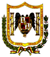
12. Coat of Arms.
